Barisan Kongō
The Kongō Range (金剛山地 Kongō Sanchi?) is a mountain range on the borders of Nara and Osaka Prefectures on the island of Honshū in the southwest of central Japan. The range separates the Osaka Plain and the Nara Basin, and forms a natural place for the boundary between the prefectures. The primary mountain in the range is Mount Kongō, and is contained within the Kongō-Ikoma-Kisen Quasi-National Park.
| Barisan Kongō | |
|---|---|
| 金剛山地 Kongō Sanchi | |
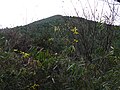
 Pemandhangan Barisan Kongō saka Gojō, Nara. Barisan Izumi ana ing sisih kiwa. | |
| Titik dhuwur dhéwé | |
| Pucuk | Gunung Kongō (Chihayaakasaka, Osaka Gose, Nara) |
| Èlevasi | 1,125 m (3,691 ft) [1] |
| Koordhinat | 34°25′10″N 135°40′23″E / 34.41944°N 135.67306°E |
| Dimensions | |
| Length | 24 km (15 mi) |
| Width | 5 km (3.1 mi) |
| Géografi | |
 Barisan Kongō | |
| Kapuloan | Jepang |
| Prefektur | Nara, Osaka and Wakayama |
| Range coordinates | 34°25′9″N 135°40′21″E / 34.41917°N 135.67250°EKoordhinat: 34°25′9″N 135°40′21″E / 34.41917°N 135.67250°E |
| Biome | Nemoral |
Geography
besutThe Kongō Range is about 24 kilometres (15 mi) long, from the Yamato River in the north to the Kino River in the south. East to West, it averages about 5 kilometres (3.1 mi) wide. The mountains in the range are from 273.6 metres (898 ft) to 1,125 metres (3,691 ft) in elevation. At Chihaya Pass, the ridgeline turns west and the Izumi Mountains begin at that point. They stretch along the border between Osaka and Wakayama Prefectures.
Mountains in the range
besutListed in order of elevation.
- Mount Kongō, 1,125 metres (3,691 ft)[1]
- Mount Yamato Katsuragi, 959.2 metres (3,147 ft)
- Iwahashi Mountain, 658.8 metres (2,161 ft)
- Mount Nijō has two peaks:
- Myōjin Mountain, 273.6 metres (898 ft)
Gallery
besut-
 Kongō cherry blossoms in spring
 -

-

-
-
 The double peaks of Mount Nijō

7.jpg)


References
besut- ↑ a b "Mt. Kongo". Osaka Convention & Tourism Info. Diarsip saka sing asli ing April 22, 2015. Dibukak ing April 22, 2015.
- ↑ a b "ダイヤモンドトレール" [Diamond Trail] (PDF) . Osaka Prefectural Government. Diarsip (PDF) saka asliné ing April 19, 2015. Dibukak ing April 17, 2015.