Barkas:1973 sinai war maps.jpg

Berkas asli (1.165 × 894 piksel, ukuran barkas: 217 KB, jinis MIME: image/jpeg)
Ringkesan
| Panyandra |
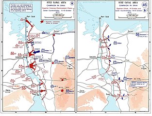
العربية: خريطة للتحركات العسكرية على الجبهة المصرية في حرب أكتوبر في الفترة بين 6 و 13 أكتوبر.
English: Sinai maps, from the US Military Academy History archives (copyright US government?)
Background information: In 1938 the predecessors of what is today The Department of History at the United States Military Academy began developing a series of campaign atlases to aid in teaching cadets a course entitled, "History of the Military Art." Since then, the Department has produced over six atlases and more than one thousand maps, encompassing not only America’s wars but global conflicts as well. In keeping abreast with today's technology, the Department of History is providing these maps on the internet as part of the department's outreach program. The maps were created by the United States Military Academy’s Department of History and are the digital versions from the atlases printed by the United States Defense Printing Agency. We gratefully acknowledge the accomplishments of the department's former cartographer, Mr. Edward J. Krasnoborski, along with the works of our present cartographer, Mr. Frank Martini. Please be aware that these maps are large in file size and may require substantial download times.. |
| Tanggal | 2005-04-220 |
| Sumber |
|
| Juru pangarang | Ondrejk |
| Vèrsi liya |
 |
Berkas ini merupakan hasil karya dari personel atau pegawai Angkatan Darat Amerika Serikat yang dibuat sebagai bagian dari tugas mereka sehingga berkas ini memiliki lisensi domain publik karena merupakan sebuah karya dari Pemerintah Federal Amerika Serikat.
|
 |
Downloaded and copied from EN-wiki
Sajarahing berkas
Klik ing tanggal/wektuné saprelu ndeleng rupané barkasé nalika tanggal iku.
| Tanggal/Wektu | Gambar cilik | Alang ujur | Naraguna | Tanggepan | |
|---|---|---|---|---|---|
| saiki | 1 Juni 2009 21.06 | | 1.165 × 894 (217 KB) | Hohum | Cleaned up |
| 20 April 2005 18.09 |  | 1.165 × 894 (174 KB) | Thuresson | larger size | |
| 20 April 2005 17.56 |  | 1.000 × 765 (63 KB) | Ondrejk | Sinai maps, from the US Military Academy History archives (copyright US government?) Source: Department of History, U.S. Military Academy {{PD-USGov}} Downloaded and copied from EN-wiki |
Panggunaning berkas
Kaca ing ngisor iki nganggo barkas iki:
Panggunané barkas sajagat
Wiki liya ngisor iki nganggo barkas iki:
- Kanggo ing af.wikipedia.org
- Kanggo ing ast.wikipedia.org
- Kanggo ing bg.wikipedia.org
- Kanggo ing ca.wikipedia.org
- Kanggo ing cy.wikipedia.org
- Kanggo ing da.wikipedia.org
- Kanggo ing de.wikipedia.org
- Kanggo ing el.wikipedia.org
- Kanggo ing en.wikipedia.org
- Kanggo ing eo.wikipedia.org
- Kanggo ing es.wikipedia.org
- Kanggo ing eu.wikipedia.org
- Kanggo ing fi.wikipedia.org
- Kanggo ing fr.wikipedia.org
- Kanggo ing gl.wikipedia.org
- Kanggo ing he.wikipedia.org
- Kanggo ing id.wikipedia.org
- Kanggo ing it.wikipedia.org
- Kanggo ing it.wikibooks.org
- Kanggo ing ja.wikipedia.org
- Kanggo ing lv.wikipedia.org
- Kanggo ing ms.wikipedia.org
- Kanggo ing ne.wikipedia.org
- Kanggo ing nl.wikipedia.org
- Kanggo ing nn.wikipedia.org
- Kanggo ing no.wikipedia.org
- Kanggo ing pl.wikipedia.org
Deleng naraguna liyané sadonya saka kaca iki.