Barkas:East Germany 1956-1990.svg

Ukuran pratayang PNG ini dari berkas SVG ini: 450 × 456 piksel Résolusi liya: 237 × 240 piksel | 474 × 480 piksel | 758 × 768 piksel | 1.011 × 1.024 piksel | 2.021 × 2.048 piksel.
Berkas asli (Barkas SVG, nominal 450 × 456 piksel, gedhéning barkas: 474 KB)
Ringkesan


.svg)
.svg)
.svg)
.svg)
.svg)


.svg)
.svg)
.svg)


.png)
.png)


.svg)


.svg)

.svg)


.svg)
.svg)
.svg)
.svg)


.svg)
.png)


.svg)


.svg)
.svg)


.svg)


.svg)


.svg)
.svg)
.svg)
.svg)
.svg)
.svg)
.svg)
_cropped.svg)
.svg)
.svg)
.svg)
.svg)
.svg)
.svg)
.svg)
.svg)
.svg)
.svg)
.svg)
.svg)
.svg)
.svg)
.svg)
.svg)
.svg)
.svg)
.svg)
.svg)
.svg)
.svg)
.svg)
.svg)
.svg)
.svg)
.svg)
.svg)
.svg)
.svg)
.svg)
.svg)
.svg)
.svg)
.svg)
.svg)
.svg)
.svg)
.svg)
.svg)
.svg)
.svg)
.svg)
.svg)
.svg)
| Ini merupakan gambar hasil penyuntingan yang berarti bahwa gambar tersebut telah diubah secara digital dari versi asli. Versi asli dapat dilihat di sini: Blank map of Europe 1956-1990.svg:
|
Lisènsi
Kula, sing nduwèni hak cipta karya iki, mawa iki nerbitaké berkas iki sakisoré lisènsi kasebut:
Barkas iki kalilakaké sangisoring palilah Creative Commons Atribusi-Andum Mèmper 3.0 Tanpa Adhaptasi.
- Kowé kena:
- ngedum – nyalin, nyebar, lan ngirim karya
- nyampur – ngolah karya
- Sangisoré kahanan mangkéné:
- atribusi – Kowé kudu mènèhi krédhit kang patut, mènèhi pranala lisènsi, lan kandha yèn ana owah-owahan. Kowé bisa tumindak sasenengmu, nanging ora teges kang duwé lisènsi njurung lakumu.
- andum mèmper – Manawa kowé nyalin rupa, ngowahi, utawa nggawé karya nganggo bahan karya iki, kowé kudu mbabar karyamu kang wis dadi nganggo lisènsi kang padha utawa kang cocog karo karya asliné..
Log unggah asli
This image is a derivative work of the following images:
- File:Blank_map_of_Europe_1956-1990.svg licensed with Cc-by-sa-3.0
- 2011-10-30T04:43:42Z Alphathon 450x456 (485146 Bytes) == {{int:filedesc}} == {{Information |Description={{en|Blank map of Europe showing national borders as they stood from 1956-1990.}} |Source=*[[:File:Blank_map_of_Europe.svg|]] |Date=2011-10-30 04:42 (UTC) |Author=*[[:File:Bla
Sajarahing berkas
Klik ing tanggal/wektuné saprelu ndeleng rupané barkasé nalika tanggal iku.
| Tanggal/Wektu | Gambar cilik | Alang ujur | Naraguna | Tanggepan | |
|---|---|---|---|---|---|
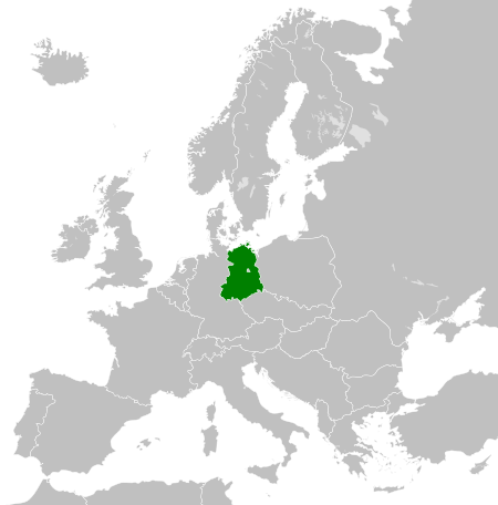
| saiki | 26 Novèmber 2011 00.33 | | 450 × 456 (474 KB) | StalwartUK | == {{int:filedesc}} == {{Information |Description={{en|Map of the East Germany (German Democratic Republic) as it was from 1949-1990. Surrounding countries accurate from 1956-1990.}} |Source=*[[:File:Blank_map_of_Europe_1956-1990.svg| |
Panggunaning berkas
Kaca ing ngisor iki nganggo barkas iki:
Panggunané barkas sajagat
Wiki liya ngisor iki nganggo barkas iki:
- Kanggo ing af.wikipedia.org
- Kanggo ing am.wikipedia.org
- Kanggo ing an.wikipedia.org
- Kanggo ing ar.wikipedia.org
- Kanggo ing ast.wikipedia.org
- Kanggo ing azb.wikipedia.org
- Kanggo ing az.wikipedia.org
- Kanggo ing ba.wikipedia.org
- Kanggo ing be.wikipedia.org
- Kanggo ing bs.wikipedia.org
- Kanggo ing ca.wikipedia.org
- Kanggo ing ce.wikipedia.org
- Kanggo ing cs.wikipedia.org
- Kanggo ing de.wikipedia.org
- Kanggo ing de.wiktionary.org
- Kanggo ing diq.wikipedia.org
- Kanggo ing el.wikipedia.org
- Kanggo ing en.wikipedia.org
- Kanggo ing en.wiktionary.org
- Kanggo ing eo.wikipedia.org
- Kanggo ing es.wikipedia.org
- Kanggo ing es.wiktionary.org
- Kanggo ing eu.wikipedia.org
- Kanggo ing ext.wikipedia.org
- Kanggo ing fa.wikipedia.org
- Kanggo ing fi.wikipedia.org
- Kanggo ing fr.wikipedia.org
- Kanggo ing fr.wiktionary.org
- Kanggo ing ga.wikipedia.org
- Kanggo ing gd.wikipedia.org
- Kanggo ing gl.wikipedia.org
- Kanggo ing gv.wikipedia.org
- Kanggo ing he.wikipedia.org
- Kanggo ing hi.wikipedia.org
- Kanggo ing hr.wikipedia.org
- Kanggo ing hr.wiktionary.org
- Kanggo ing hsb.wikipedia.org
- Kanggo ing hu.wikipedia.org
- Kanggo ing hy.wikipedia.org
- Kanggo ing ia.wikipedia.org
- Kanggo ing id.wikipedia.org
- Kanggo ing is.wikipedia.org
- Kanggo ing it.wikipedia.org
Deleng naraguna liyané sadonya saka kaca iki.