Barkas:NEAT GBT engl.png

Gedhéning pratuduh iki: 539 × 600 piksel Résolusi liya: 216 × 240 piksel | 431 × 480 piksel | 852 × 948 piksel.
Berkas asli (852 × 948 piksel, ukuran barkas: 1,91 MB, jinis MIME: image/png)
Ringkesan
| Panyandra |
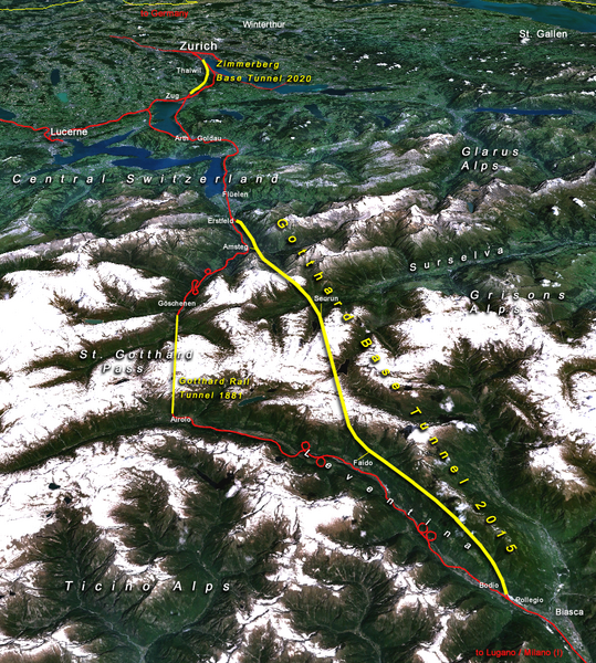
Situation of the northern part of the Gotthard axis as part of the New Railway Link through the Alps NRLA / Alptransit project in Switzerland with Gotthard and Zimmerberg base tunnels |
| Tanggal | |
| Sumber | topomap: produced with NASA WorldWind 1.3 / overlay drawing by: Cooper.ch |
| Juru pangarang | --Cooper.ch 19:30, 12 August 2006 (UTC) |
| Idin (Nganggo manèh barkas iki) |
NASA satellite imagery is in public domain, and so is my overlay drawing |
| Vèrsi liya | Original german version on de.wikipedia.org, named Bild:NEAT_Gotthardachse.png |
Lisènsi
| Berkas ini berada dalam domain publik di Amerika Serikat karena semata-mata diciptakan oleh NASA. Kebijakan hak cipta NASA menyatakan bahwa "materi NASA tidak dilindungi oleh hak cipta kecuali dicatat". (Lihat Template:PD-USGov, Halaman kebijakan hak cipta NASA atau JPL Image Use Policy.) | ||
 |
Peringatan:
|
| Annotations | This image is annotated: View the annotations at Commons |


Sajarahing berkas
Klik ing tanggal/wektuné saprelu ndeleng rupané barkasé nalika tanggal iku.
| Tanggal/Wektu | Gambar cilik | Alang ujur | Naraguna | Tanggepan | |
|---|---|---|---|---|---|
| saiki | 12 Agustus 2006 19.30 | | 852 × 948 (1,91 MB) | Cooper.ch | {{Information |Description=Situation of the northern axis of the New Railway Link through the Alps NRLA in Switzerland with Gotthard and Zimmerberg base tunnels |Source=topomap: produced with NASA WorldWind 1.3 / drawing overlay by: [[User:Cooper.ch|Coope |
Panggunaning berkas
Kaca ing ngisor iki nganggo barkas iki:
Panggunané barkas sajagat
Wiki liya ngisor iki nganggo barkas iki:
- Kanggo ing ast.wikipedia.org
- Kanggo ing bh.wikipedia.org
- Kanggo ing da.wikipedia.org
- Kanggo ing en.wikipedia.org
- Kanggo ing es.wikipedia.org
- Kanggo ing fa.wikipedia.org
- Kanggo ing fi.wikipedia.org
- Kanggo ing fr.wikipedia.org
- Kanggo ing he.wikipedia.org
- Kanggo ing hr.wikipedia.org
- Kanggo ing ja.wikipedia.org
- Kanggo ing ml.wikipedia.org
- Kanggo ing my.wikipedia.org
- Kanggo ing nl.wikipedia.org
- Kanggo ing no.wikipedia.org
- Kanggo ing pt.wikipedia.org
- Kanggo ing rm.wikipedia.org
- Kanggo ing ro.wikipedia.org
- Kanggo ing sh.wikipedia.org
- Kanggo ing sl.wikipedia.org
- Kanggo ing sv.wikipedia.org
- Kanggo ing ta.wikinews.org
- Kanggo ing tr.wikipedia.org
- Kanggo ing zh.wikipedia.org