Barkas:View towards Y Lliwedd from the summit of Yr Wyddfa-Snowdon - geograph.org.uk - 702192.jpg
Ora ana résolusi kang luwih dhuwur.
View_towards_Y_Lliwedd_from_the_summit_of_Yr_Wyddfa-Snowdon_-_geograph.org.uk_-_702192.jpg (640 × 480 piksel, ukuran barkas: 181 KB, jinis MIME: image/jpeg)
Ringkesan
| Panyandra |
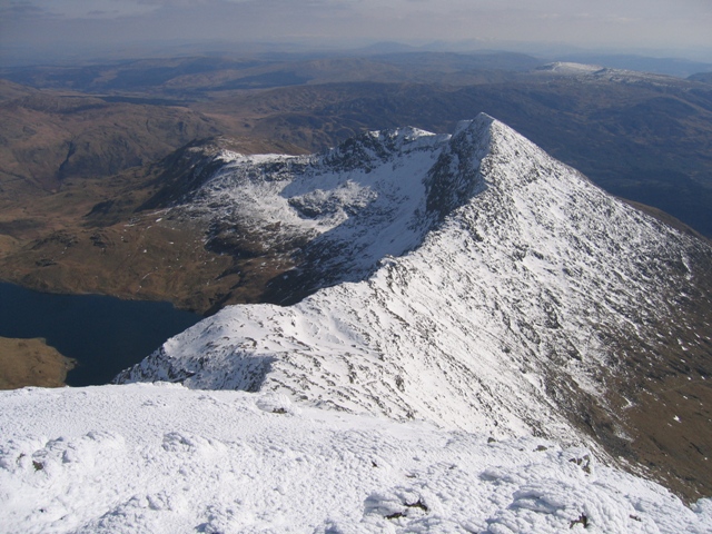
English: View towards Y Lliwedd from the summit of Yr Wyddfa/Snowdon Taken from the highest part of Yr Wyddfa looking along the ridge towards Y Lliwedd. The Watkin Path follows the ridge on the south side (right) and then turns south for lower ground as the path starts to rise towards Y Lliwedd. Llyn Llydaw is far below to the left. |
| Tanggal | |
| Sumber | From geograph.org.uk |
| Juru pangarang | John S Turner |
| Atribusi (required by the license) | John S Turner / View towards Y Lliwedd from the summit of Yr Wyddfa/Snowdon / |
| Lokasi kamera | | Lihat gambar ini dan gambar di sekitarnya di: OpenStreetMap |
|---|
_heading:135.00&language=jv)
| Lokasi objek | | Lihat gambar ini dan gambar di sekitarnya di: OpenStreetMap |
|---|
_heading:135.00&language=jv)
Lisènsi

|
This image was taken from the Geograph project collection. See this photograph's page on the Geograph website for the photographer's contact details. The copyright on this image is owned by John S Turner and is licensed for reuse under the Creative Commons Attribution-ShareAlike 2.0 license.
|
Berkas ini dilisensikan di bawah lisensi Creative Commons Atribusi-Berbagi Serupa 2.0 Generik
Atribusi: John S Turner
- Kowé kena:
- ngedum – nyalin, nyebar, lan ngirim karya
- nyampur – ngolah karya
- Sangisoré kahanan mangkéné:
- atribusi – Kowé kudu mènèhi krédhit kang patut, mènèhi pranala lisènsi, lan kandha yèn ana owah-owahan. Kowé bisa tumindak sasenengmu, nanging ora teges kang duwé lisènsi njurung lakumu.
- andum mèmper – Manawa kowé nyalin rupa, ngowahi, utawa nggawé karya nganggo bahan karya iki, kowé kudu mbabar karyamu kang wis dadi nganggo lisènsi kang padha utawa kang cocog karo karya asliné..
Sajarahing berkas
Klik ing tanggal/wektuné saprelu ndeleng rupané barkasé nalika tanggal iku.
| Tanggal/Wektu | Gambar cilik | Alang ujur | Naraguna | Tanggepan | |
|---|---|---|---|---|---|
| saiki | 18 Fèbruari 2011 23.39 | | 640 × 480 (181 KB) | GeographBot | == {{int:filedesc}} == {{Information |description={{en|1=View towards Y Lliwedd from the summit of Yr Wyddfa/Snowdon Taken from the highest part of Yr Wyddfa looking along the ridge towards Y Lliwedd. The Watkin Path follows the ridge on the south side ( |
Panggunaning berkas
Kaca ing ngisor iki nganggo barkas iki:
Panggunané barkas sajagat
Wiki liya ngisor iki nganggo barkas iki:
- Kanggo ing en.wikipedia.org
- Kanggo ing es.wikipedia.org
- Kanggo ing fr.wikipedia.org
- Kanggo ing sl.wikipedia.org