Florida
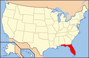
Florida (IPA: /ˈflɒrɪdə/) iku praja ing Amérika Sarékat dumunung ing sisih kidul-wétan. Tlatah praja iki racaké awujud jasirah utawa ujung gedhé kanthi Lempongan Meksiko ing sisih kulon lan Samodra Atlantik ing sisih wétan. Florida duwé iklim subtropis; lan ing tlatah sisih kidul iklim tropis.[3] Florida dijenengaké déning Juan Ponce de León, sing ndharat ing jasirah iki tanggal 2 April, 1513, sajeroning Pascua Florida (Spanyol tumrap Paskah kebak kembang utawa Flowery Easter, tegesé mangsa Paskah). Florida iku praja nomer papat paling padhet sing ndunungi Amérika Sarékat.[4][5]
| State of Florida | |||||||||||
| |||||||||||
| Basa resmi | Inggris | ||||||||||
| Démonim | Floridian | ||||||||||
| Ibukutha | Tallahassee | ||||||||||
| Kutha paling gedhé | Jacksonville | ||||||||||
| metro area paling gedhé | Miami | ||||||||||
| Area | Ranking 22nd ing AS | ||||||||||
| - Total | 65,795[1] sq mi (170,304[1] km²) | ||||||||||
| - Jembar | 361 miles (582 km) | ||||||||||
| - Dawa | 447 miles (721 km) | ||||||||||
| - % banyu | 17.9 | ||||||||||
| - Garis lintang | 24°27′ N to 31° N | ||||||||||
| - Garis bujur | 80°02′ W to 87°38′ W | ||||||||||
| Populasi | Rangking 4th ing AS | ||||||||||
| - Total | 15,982,378 (18.25 yuta taun 2007) | ||||||||||
| - Kapadhetan | 309/sq mi 117.3/km² (8th in the US) | ||||||||||
| - Median income | $41,171 (36th) | ||||||||||
| Elevasi | |||||||||||
| - Titik paling dhuwur | Britton Hill[2] 345 ft (105 m) | ||||||||||
| - Mean | 98 ft (30 m) | ||||||||||
| - Titik paling cendhèk | Atlantic Ocean[2] 0 ft (0 m) | ||||||||||
| Mlebu Union | March 3, 1845 (27th) | ||||||||||
| Gubernur | Charlie Crist (R) | ||||||||||
| Lètnan Gubernur | Jeff Kottkamp (R) | ||||||||||
| Senator | Bill Nelson (D) Mel Martinez (R) | ||||||||||
| Delegasi Konggrès | List | ||||||||||
| Zona wektu | |||||||||||
| - peninsula | Eastern: UTC-5/DST-4 | ||||||||||
| - panhandle | Central: UTC-6/DST-5 | ||||||||||
| Cekakan | FL Fla. US-FL | ||||||||||
| Situs web | www.myflorida.com | ||||||||||
Kembaran
besutRujukan
besut- ↑ a b "2000 Census" (ZIP). US Census Bureau. Dibukak ing 2007-07-18.
- ↑ a b "Elevations and Distances in the United States". U.S Geological Survey. 29 April 2005. Diarsip saka sing asli ing 1 June 2008. Dibukak ing 3 November 2006.
- ↑ "Köppen Climate Classification Map". John Abbott College, Geosciences Department. Dibukak ing 2007-07-18.
- ↑ sawisé California, Texas, lan New York
- ↑ United States population by states Archived 2009-04-03 at the Library of Congress, United States Census Bureau.
Pranala njaba
besut| Andharan saka Wikibausastra | |
| Médhia saka Commons | |
| Warta saka Wikinews | |
| Cuplikan saka Wikiquote | |
| Tèks saka Wikisource | |
| Buku tèks saka Wikibooks | |
| Matèri sinau saka Wikiversity | |
- State website
Wikiplesir duwé panuntun plesir ngenani Florida. - Florida Memory Project Over 300,000 photographs and documents from the State Library & Archives of Florida
- Online collection of the Spanish Land Grants.
- History topics timeline of Florida 1795-1895 Archived 2009-06-14 at the Wayback Machine.
- USGS real-time, geographic, and other scientific resources of Florida
- University of Florida Digital Collections Digital collections of texts and images, including Florida aerial photography, ephemeral photographs and postcards, letters, and more
- U.S. Census Bureau Archived 2012-08-14 at the Wayback Machine.
- Economic and farm demographics fact sheet from the USDA Archived 2010-07-09 at the Wayback Machine.
- Energy & Environmental Data For Florida
- List of searchable databases produced by Florida state agencies Archived 2009-04-20 at the Wayback Machine. hosted by the American Library Association Government Documents Roundtable Archived 2009-10-13 at the Wayback Machine..
Artikel gegayutan Amérikah Sarékat iki minangka artikel rintisan. Kowé bisa ngéwangi Wikipédia ngembangaké.


